 |
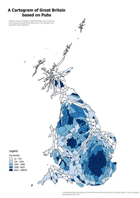
| Cartogram of Local Authority areas in Great Britain based on numbers of pubs on OpenStreetMap Created using ScapeToad, this is a simple, and naive, cartogram. |
Tuesday 19 May 2015
Retail Outlets on OpenStreetMap: Cartograms, and Patchwork Quilts
I enjoyed the process of creating a cartogram from OpenStreetMap data a couple of years back, even if it was somewhat tedious. However two things stopped me from taking it further: the QGIS plugin I was using does not work with later editions, and I really wanted something a little more refined.
Monday 4 May 2015
Documenting Footpaths with Mapillary
I have long been a believer in the need to document OpenStreetMap survey data as thoroughly as possible.
I have a large archive of audio files, GPS traces, and tens of thousands of photographs. These span back to late 2008 when I started contributing to OSM. From time to time these prove useful, for instance, I had very precise documentation for my evidence at a Public Enquiry.
However, sharing such archival information with other mappers is difficult. It's not even straightforward for me to locate stuff. I have used OpenStreetView (OSV) since it was announced at SotM Girona. It is difficult to share photos using OSV, and the interface has not developed since 2010.
I was therefore very interested to learn about Mapillary, but was initially put off by the licensing. When they changed the licensing I was more interested. At SotM-EU Karlsruhe I was able to chat with Yubin after hearing his talk, which convinced me to give it a go. As I've said before, I regret I did not do this the following morning when full documentation of our walk at the Weingartnermoor would have been very useful, not just for mapping this particular place, but for discussing how to map woodland.
I don't have an Android phone which is compatible with Mapillary so I have had to do things manually. This is a little tedious, so I tend to keep the creation of sequences for things which are either simple or of particular value.
Subscribe to:
Posts (Atom)